big question: What are the different ways cities are used?
|
Reflections from the clip
1. How did the landscape change during the video? 2. What was similar with the houses at the beginning and end of the video? 3. What differences did you observe? 4. How did transport change during the video? 5. Can you name any places that you saw in the video? |
|
What is 'land use'?
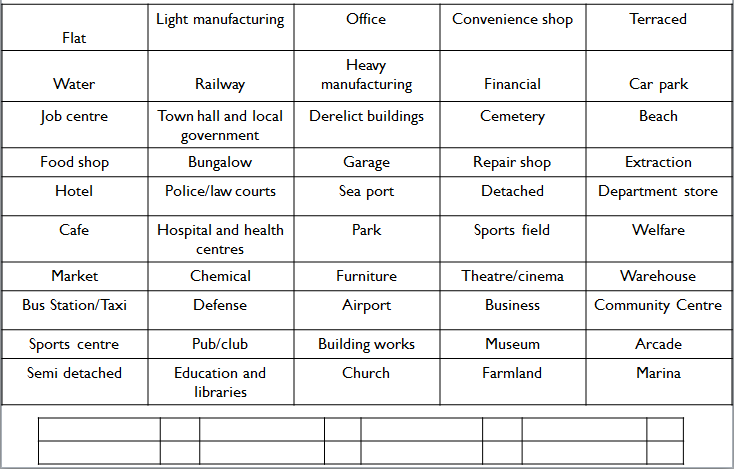
Can you create categories for the following land uses? What do you think land use means? How has land use changed over time? How could it change in the future?
Can you create categories for the following land uses? What do you think land use means? How has land use changed over time? How could it change in the future?
Land use and the Burgess model
|
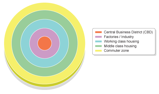
Geographers have put together models of land use to show how a 'typical' city
is laid out. One of the most famous of these is the Burgess or concentric zone model. This model is based on the idea that land values are highest in the centre of a town or city. This is because competition is high in the central parts of the settlement. This leads to high-rise, high-density buildings being found near the Central Business District (CBD), with low-density, sparse developments on the edge of the town or city. (Taken from BBC Bitesize) |
Creating a 3D Burgess Model: Circles and photos in the link below.
How useful is the Burgess Model today? Creating a land use model for a city or your choice. Use the document here and use Google Earth to locate each of the land uses.
Reflection...
To what extent is the Burgess Model still relevant today? What are it major limitations?
To what extent is the Burgess Model still relevant today? What are it major limitations?